Data Through Design 2022
In March 2022 Ground Truth IRL presented work that considered the theme in light of all that had passed in the previous year. With a combination of projects from 2021 and 2022, the 2022 exhibition presented 12 multi-disciplinary projects ranging from performance, installation, projects built with analog processes such as drawing, dying and weaving to technology driven projects using robotics to create weavings based on city parks data. After an unprecedentedly long time of virtual gatherings DxD finally took place In Real Life, at The Hall galley space in Brooklyn Navy Yards.

Theme: Ground Truth IRL
Data Through Design’s Ground Truth IRL is a continuation and expansion of the 2021 DxD virtual exhibit, Ground Truth. As much as things have changed from last year, many familiar challenges remain unresolved, and as we transition back (or forward?) to an in-person, “In Real-Life” gallery experience, new works will be presented along with the works shown virtually in 2021, this time with fresh meaning and resonance.
2022 Projects
99 cents & Up & Up
Gloria Lau and Daphne Lundi
99 cents store, dollar store, discount store, bargain store, variety store, dollar tree. These places have many names and represent a ubiquitous but oftentimes invisible part of New York City's landscape. In many neighborhoods, particularly in low-income and Black and brown communities, where major chains or supermarkets choose not to locate, 99 cents stores fill in the gap and can serve as places for purchasing low-cost food, home goods, school supplies, beauty products, and clothing. Even though the demand of these stores is the result of exclusion, they have also become resources for creativity and homemaking, allowing people to DIY projects, and make improvements to their homes while spending a relatively small amount of money. No two 99 cents stores are the same: some are chain stores that made a calculated decision to locate in low-income neighborhoods, but many are mom-and-pop shops that provide immigrant communities the opportunity for business ownership.

Blue Lines + Future Coral
Jeff Fossett, Evan Finkle, and Jesse Bryant
In the broadest sense, this project is meant to render sensible the growing socio-environmental problems involving water, New York, and the climatic future. Like all problems tethered to climate change, these problems are both material and political. First, there is the increased material threat of flooding that will no doubt continue to rise as global temperatures grow and meteorological systems become less stable. But second, there is the financial threat of bluelining, or the insurance company practice of incorporating flood models into profit calculations and thus in some neighborhoods discontinuing flood insurance, or further, no longer offering 30-year mortgages.
Blue Lines + Future Coral uses US Census data, neighborhood-level demographic data, and flood data from the 2020 and 2050 models to visualize waves of displacements within neighborhoods in New York, first due to the inaccessibility of credit and second due to inevitable flooding.

Compositions: NYC
Julia Bloom, Sukanya Aneja, and Michael Hsu
Listeners are invited to toggle between field recordings and generated soundscapes, and may read an accompanying description to help them understand what they are hearing. They can also visit the locations in person to ground truth the fidelity of the generated soundscapes for themselves.
In some cases, listeners may find that the artificial NYC soundscape heightens their awareness of certain noises of the city. They may notice the presence or absence of birds chirping, diners laughing over lunch, the wind, the rain, or the rumbling of a train passing underfoot. The artificial soundscapes may also exaggerate the frequency and intensity of “nuisance” noises like construction, loud pedestrian conversation, street traffic, and so on. They might even find that there is some agreement between the computer-generated soundscapes and the field recordings. Perhaps they will find, as we did, that so much of the character of a city depends, in fact, on the time of day, the weather, or the moods of passersby—the countless coincidences from which emerges the sounds of life.
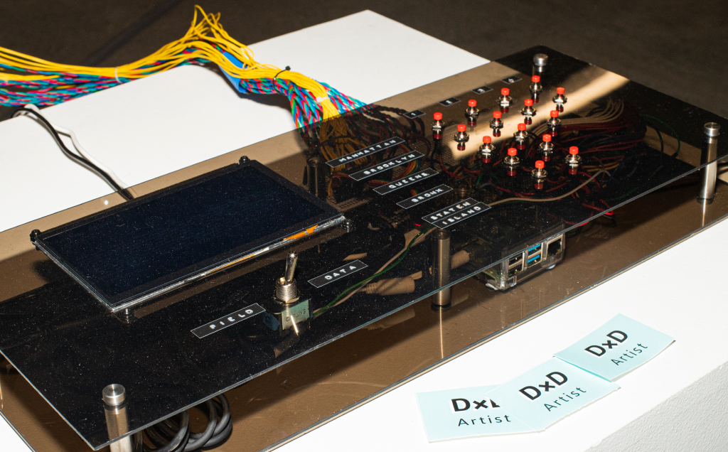
Counterpoints
Mansi Shah, Lucy Hatem, and Torstein Johansen
Counterpoints is a site-specific performance designed to explore boundaries between data and reality, define a sense of place, and test the limits between remote observation and experience. This project reimagines the idea of a musical score, using geospatial and publicly available urban data as a basis for improvisation and spontaneous composition and offering viewers a way to experience a physical location on various levels at once.
How has our understanding of place, and specifically what it means to be in a physically embodied space during a global pandemic, shaped our experience of our surroundings? Time series satellite imagery of locations around Brooklyn and Manhattan from 2018 through 2021 show changes over time, while data from NYC’s Open Data collection (converted into prose scores) is interpreted by the performers. This data informs the audio improvisations and presents ways to experience and explore a sense of place from multiple perspectives simultaneously.

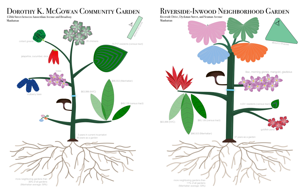
Every Row is a Garden
Alec Barrett
Every Row is a Garden is a series of data portraits depicting five community gardens in Manhattan, Brooklyn, and the Bronx. The portraits show data from a variety of sources including the city’s open data portal, the U.S. Census, and the artist’s firsthand visits to the gardens and conversations with volunteers who tend them. The portraits use experimental graphical forms inspired by ecological and botanical shapes to visually represent qualitative and quantitative data.
When indoor spaces and close human contact present new risks and digital media consume an ever growing share of our time and attention, community gardens offer an escape outdoors to experience something local, natural, and real. Thanks to the Parks Department, land trusts, and small nonprofits, these plots resist—to our collective benefit—the tendency in NYC real estate toward privatization and profit. Community gardens, like the rest of us, contend with pests, noisy neighbors, bureaucracy, and demographic change. Most gardens have cohorts of members who pay dues, but rely on the dedicated, thankless labor of a handful of core volunteers.
Feel My City Breaking & Everybody Shaking
Jennifer Dalton
The project began in the anxious period surrounding the initial New York City lockdown, when residents were commanded to “PAUSE” and the calendar was suddenly wiped clean; every routine was upended, yet life somehow still proceeded hour by hour, day by day. I quickly realized I had no idea where the time was “going,” and craved a structure to cling to. I created customized daily time cards to represent the Groundhog Day feeling of punching a clock at home, every day nearly identical to the one before, and logged my activity in half-hour handwritten color-coded increments. Each day’s card is stamped with the date and hand-inscribed with the morning headline from the New York Times, the local weather, a quote from then-Governor Cuomo’s latest press conference, and the top trending hashtag on Twitter. Each time card is hinged to the next in succession, creating a long continuous accordion book upon which fluorescent-color line graphs rise and fall from one day to the next, representing daily pandemic, economic and cultural information and elucidating the relationship between my individual ordinary activity and the news, trends and metrics of the outside world.

Finding Your (Softer) Edge
Works on Water
Direct contact with waterfronts is essential to the life of New York City, but we are caught between many different social versions of what that waterfront space does, should, and can mean. The “truth” of the waterfront is multi-layered–it is an industrial space, a living space, a space of nature, a space for real estate speculation–as diverse, difficult and deeply moving as the city itself. In 2019, Works on Water (WoW) began collaborating with the Waterfront and Open Spaces Division of the NYC Department of City Planning and arts organization Culture Push on Walking the Edge, originally planned as an opportunity for New Yorkers of all abilities and ages, in every borough, to experience and express their waterfront. As part of the research process, members of WoW and of the DCP WOS team performed a series of ground-truthing walks, guided by NYC Open Data and the DCP’s own database. We found, in our own ground-truthing process, that our discoveries, though deeply informed by the available spatial data, brought in often unexpected levels of complexity and difficulty.

New York Alive!
Jen Ray and Jason Forrest
Join artist Jen Ray and data designer Jason Forrest as they present a not-entirely-serious exploration of the urges, needs, and desires of New York City residents – both officially in the data, as well as through informal survey results. Inspired by historic influences such as Otto & Marie Neurath Isotype designs and the Triadic Ballet of the Bauhaus, this performance will be a celebration of the city, echoing the interests that make our shared culture so unique. By incorporating movement, props, pictorial statistics, music, megaphones, and good humor we guarantee you've never seen data presented in this way before!

Our Neighbors: Urban Animals of New York
Nancy Smith
Our Neighbors: Urban Animals of New York highlights the wide variety of animals that live in New York City. The piece is about cohabitation, shared resources, and diverse landscapes. The design utilizes natural materials gathered from the many NYC parks that animals call home, including things such as leaves, branches, pinecones, rocks, dirt, and other organic matter. In most data sets, we don’t get a tangible sense of what is behind the data, but nature is something that provides us with a very sensory experience. In this case, it is not only the animals themselves that we may interact with, but perhaps more often the natural habitats we all share. This piece is an experiment in playing with spatialization of data as the colors of the threads and placement of the globes (within the frame) corresponds to data points collected about where animals live, their health, and the seasons that shape our experience of the outside world. The accompanying posters provide a more concrete visualization of the Urban Park Ranger Animal Condition Response Data Set and offer a key to read the representations that are built into the sculpture. This piece helps people to think about all the nonhuman animals that share urban space and its many landscapes with us.

Parks x Needle
Sally Kong and Owen Trueblood
Parks x Needle is a tactile visualization of the NYC Park’s Forever Wild’s ecologically important natural resources. There are four key components in producing this park visualization: NYC Parks for providing the shapes of the wildlife zones, a visual effects software (Houdini) for procedurally generating the stitches and paths, a tufting gun mounted robot arm to stitch based on a given path, and the artists’ park excursions to find the yarn’s color palette that reflects their experience of the NYC parks in all five boroughs. This project hopes to provide a fun, novel, and cozy experience for the audience to interact with the expansive parks at an intimate scale as well as spark a sense of exploration and play.

Shadow Tag
Cindy Stockton Moore, Rachel Blake, John Stockton, Hoang Pham, and Rachel Wetzel
‘Shadow Tag’ is a new experimental video exploring the unseen in the OpenCity data – using a layered technique to search for traces of children, who are underrepresented in the metrics but always present, alongside impactful environmental factors. Visualizing signal extraction through hand-drawn animation, charts, and maps, the video presents an abstracted narrative that explores the concept of observability –and its twin controllability– through the open-structure of play. Animations, created using chalk erasure and stop motion, occur directly on the street; data is redrawn within children’s environments, offering affordances for free play and adaptation. The atmospheric soundtrack is initially generated by TwoTone data but then layered and looped, a connected distortion reflecting the resilient joy of ‘Shadow Tag.’

Wasted Potential
Renée Crowley
The City’s datasets show that more and more food waste is making its way to a compost site each year. “Wasted Potential” opens up the dialogue around this data and questions how we might recognize that edible food contributes to those growth rates. Simultaneously, NYC faces growing rates of residents facing food insecurity that has been further exacerbated by the COVID-19 pandemic and corresponding economic crisis. This piece opens our minds to the untapped potential of our food waste and asks: “how can edible food be rescued from our waste stream and feed those in need”.
To create the pigments in this work, Renée sifted through the compost waste stream to find reusable resources for dyeing. This process driven action of utilizing recovered food waste to dye yarn, grounds the project in what NYC’s food waste tonnage data actually looks, smells and feels like up close.

Sponsors
NYC Mayor’s Office of Data Analytics
Pratt SAVI
Brooklyn Arts Council
2022 DxD Organizers
Can Sucuoglu, Elen Oh, Justin Roberts, Jack Darcey, Jessie Braden, Julia Bloom, Rachel Daniell, Sara Eichner, Sofia Martynovich
Photography by Jessie Yu Chen and DxD organizers